 |
| Mount Arjuno |
Mt.Arjuno
(sometimes spelled Mount Arjuna) is a stratovolcano (break) in East
Java, Indonesia with an altitude of 3,339 m above sea level. Mt.Arjuno
is administratively located in the border town of Batu, Malang and
Pasuruan and is under the management of Forest Park Raden Soerjo. Mt.Arjuno
is the third highest mountain in East Java after Mount Semeru and Mount
roar, as well as being the fourth highest in Java. Usually this is achieved from three mountain climbing point is well known that from Lawang, Tretes and Batu. Arjuno name comes from one of the puppet character Mahabharata, Arjuna.
Mt.Arjuno adjacent to Mount Welirang, mountain Twins I and Twins II mountain. Mt.Arjuno peak lies on the same ridge by mountain peaks Welirang, so that the complex is often referred to as Arjuno-Welirang. Arjuno-Welirang complex itself is in two older volcanoes, Mount Ringgit to the east and Mount Lincing in the south. Area fumarole with sulfur reserves are found in a number of locations
these mountains, such as the summit of Mount Welirang, the summit of
Mount Twins II, and a number of hiking paths.
Mt.Arjuno is one climbing destination. In addition to the height which has reached more than 3000 meters, this mountain there are a few attractions. One of them is the waterfall tourist attraction Grandfather Bodo is also a hiking trail to the summit Mt.Arjuno. Although
Attraction besides Grandfather Bodo waterfall there is also another
waterfall, but tourists rarely come other waterfalls, probably because
of the location and tourist facilities are less supportive. In the area of its slopes there are also springs from the Brantas River water deposits Mt.Arjuno. Brantas River springs located in Sumber Brantas, Bumiaji, Batu which is the second longest river in Java after the Solo River. Some of the famous tourist destinations up to the rest of Indonesia
and abroad are also located on the slopes of Mt.Arjuno, among which are
Tretes, Batu and Taman Safari Indonesia 2.
Mt.Arjuno has a forest area Dipterokarp Hill, Dipterokarp forest Upper
Montane forest, and forest Ericaceous or mountain forests.
Mt.Arjuno
can climb and a variety of directions, towards the North (Tretes)
through Mount Welirang, and the East (Lawang) and from the West
(Stone-Selecta), and south (Karangploso), also from Sumberawan,
Singosari. Sumberawan
village is the village handicraft center in the district Singosari,
Malang and is the last village to prepare before starting the ascent. Purwosari can also pass more easily bypassed, because only half an hour from the highway and immediately got Tambakwatu.
Source: Wikipedia
 |
| Coban Rondo Waterfall |
Coban Rondo Waterfall is a waterfall located in Pujon, Batu, Malang, East Java. This waterfall is easily accessible by public transport.
The easiest access is by road from Malang to Ayers from the east or from Kediri Pare to Malang from the west.
In 2015, ticket for Rp 15,000.00 per person while the parking rates for two-wheeled vehicles is Rp 4000.00.
Coban Rondo is situated at an altitude of 1135 m above sea level. This waterfall has a height of 84 meters and the water discharge is
around 90 liters per second during the dry season up to 150 liters per
second in the rainy season.
Coban Rondo is actually a part of a tiered waterfall group (starting
with the twin waterfalls named Coban Manten, which merge into one called
Dudo Coban, and then flows down to the name of Coban Rondo).
The legend that is exactly Goddess Anjarwati of Gunung Kawi and Raden Baron Kusumo from Mount Anjasmoro who fall in love. Both decided to tie the knot in marriage.
Just a few days to be husband and wife, Dewi Anjarwati invite him to come to their parents' home in Mount Anjasmoro. This intention was opposed by parents Dewi Anjarwati. According to an ancient Javanese tradition, the newlyweds were forbidden to travel before reaching the age of marriage selapan. It is believed to bring bad luck for the couple. But both still insisted on going.
Along the way, the Goddess Anjarwati and Raden Kusumo Baron met with Joko Lelono. Apparently foreigners lured Anjarwati goddess of beauty at first sight. Joko Lelono Raden Baron was challenged to fight a duel Kusumo Goddess Anjarwati. The wife asked to hide themselves behind the waterfall while waiting for her husband to come pick.
Not unexpectedly, Raden Baron and Joko Lelono Kusumo and equally killed in the fight. Baron Raden Kusumo promise to pick up his wife can not be filled. Stay Dewi Anjarwati widow lament his fate behind the waterfall.
 |
| Sendang Biru Beach |
 |
| Sempu Island |
Sendangbiru
beach is a beach on the south coast which is situated on the edge of
the ocean Indonesia is administratively located in the hamlet
Sendangbiru, Tambakrejo Village, District Sumbermanjing Wetan, Malang,
East Java [1]. Sendangbiru beach is one wanawisata owned by Perum Perhutani and managed by KBM JLPL Unit II. Situated
on plots 81 and 86 with standard acreage of 50 ha and 3 ha area
benefits, RPH Sumber Agung, BKPH Sumbermanjing, KPH Malang belongs to
the class of protected forest. Distance from Malang approximately 67 kilometers and takes about 2-2.5 hours to get to the beach Sendangbiru. The only means of transport is private car, because there is no public transport that pass in there. The beach is not far away from the coast of Goa China, it takes only about 15 minutes by motor vehicle. From JLS entrance to the beach was also paved. Only some roads are asphalt peeling. Turkish Sendangbiru first opened in 1970. It's just that time was a local fisherman. Only in the 1980s, fishermen from outside the area also go into Sendangbiru. That's because the construction of a fish landing bases Pondokdadap in 1980-1989.
The
beach is directly opposite the island Sempu, only separated by a narrow
strait Sempu and with a length of approximately 4 kilometers. In this strait suitable for boating or other water sports because of its location sheltered by the island Sempu. Therefore, this beach is usually used as an entrance to the island's famous Sempu with naturalness. Their island Sempu become its own attraction Sendangbiru Beach. Sempu Island, a nature reserve that berdanau full freshwater catfish in the middle of the forest and the sea water lake. One attraction of this beach is a fish market at the fish auction (TPI) and travel diesel engined boat ride around the coast. The majority of tourists who come to ride the boats and fresh fish shop because the price is very cheap. The price of fish follows the seasons, so that if by the time the tide was high price of fish is expensive. The
marine products can be found in Sendangbiru include pelagic fish
species that lemurung, overpasses, anchovies, tuna, mackerel, and squid.
As for the type damersal among other rays, grouper, sea bass, red
snapper and white pomfret and other types of export commodities such as
tuna, mackerel, swordfish, lobster, sea cucumbers and seaweed.
Currently Sendangbiru Coastal scenery was looking like it used to be. Moreover, on the shoreline just filled with fishing boats and sometimes looks a bit dirty on the coast. Severe abrasion on the west coast. The view was also not get out much because of blocked Sempu Island. Visitors
can sit around the beach while enjoying the island Sempu from afar and
see the bustle of the fishermen to fish and lean on the beach. On a normal day, there is indeed a lot of visitors to the beach. Moreover, in Sendangbiru you can go swimming, fishing and boating. Here already provided a parking area, toilets, rooms, shelter, viewing tower, the information center, and food stalls. At
the time of the days Syawalan, which is about 7-8 Syawal, many boating
to the island Sempu to fetch water from a fresh water springs that can
be trusted to health and healing. Whereas every year, precisely on September 27, local residents held a stringed sea (sea alms).
Sights in Turkish Sendangbiru quite interesting. Actually, the clean white sand and clear blue sea water makes a beautiful view. Fishing boat colorful leaning neatly on the waterfront. The ships are not only used as a means for fishing, but is also rented out to tourists. You can hire a ship to tour around the coast. Fees are set not too expensive, only Rp 100,000 to Rp 50,000 boat and rowed to the ship. In the midst of the sea, you can see to the bottom. There underwater sights are clearly visible. Small fish swimming between coral reef make your experience visiting Turkish Sendangbiru will not be forgotten. The boat can be driven up to 12 people.
The
existence Sendangbiru famous beach, it can not be separated from the
spring (springs) at the bottom of the hill where the water is blue. Spring that is the forerunner of the beach is called Sendangbiru until today. The position of the spring about 1 kilometer from the west coast. From the coast up to the village heading south traffic lane (JLS). In the left JLS from the coast there is a path toward the bottom of the hill. That's where there are sources of water that ranged between 10 x 8 meters with a depth of 2.5 meters. Water color blue. There are two spring in the region. In addition there is also a Sendanggambir Sendangbiru. However Sendangbiru larger water discharge. Of the two spring that neighborhood residents Sitiarjo and surrounding areas depend.
Source: Wikipedia
 |
| Balekambang Beach |
Balekambang
Beach is a beach on the south coast which is located on the edge of the
Indonesian Ocean administratively entrance area Source Jambe Hamlet,
Village Srigonco, District Bantur, Malang, East Java and is one of
the mainstay attractions Malang district since 1985 until now. The
main appeal of course Balekambang natural landscapes, huge waves and
extending nearly two kilometers, as well as the sandy expanse. White sand area looks clean of trash and dirt so it is quite convenient for visitors to play and exercise. In fact, not infrequently at the beach is a place to practice a number of football clubs such as Arema and Persema.The
beach began to grow and visited by the general public in 1978, after
the opening of access roads do Kadesh Srigonco Tukiran. Balekambang
name becoming known after officially opened as one of the sights by
Regent, Eddy Slamet in 1983. At that time the road was already
dimakadam. The beach was also unveiled as a scout camp Malang. Now,
access to Balekambang already easy and convenient, visitors only
difficulty when it is in the Canyons Mayit due incline sharp cornering. However, the road is paved smooth as access Nice, it took no more than
30 minutes away from the district town of Bantur to Balekambang.Turkish Balekambang continue to improve, a number of additional facilities offered by the management, one flying fox. The game was launched since August 2012, but the flying fox is only open every Saturday and Sunday. In addition to flying fox, games for children are also an attraction. Various variants of toys such as swings, a complete animal sculpture available. Even shortly be provided rental ATV.Turkish Balekambang aside as nature, can also be referred to as a religious tourism. Because on certain days, thousands of visitors come to this beach to perform the ritual. For Muslims, they undergo a ritual to visit the tomb of Sheikh Abdul Jalil, the first clearing Balekambang Beach. Each
1 Sha'ban, the pilgrims spilling over into the tomb that is secluded at
the edge of Kali Berek, located about 1 km before entering Turkish
Balekambang of Bantur direction. The origin of Sheikh Abdul Jalil reportedly came from Jogjakarta. He was a noble family who have religious knowledge is quite high, because it is so strong influence in the community. Moreover, Sheikh Abdul Jalil including those that do not want to
compromise the Dutch colonists, Dutch karenamya make it as people who
should be excluded.Besides Muslims, Hindus also make this beach as the main place of worship once a year. Precisely on Nyepi, located in Amarta Pura Jati on the island Ismoyo. The island is indented in from the shoreline about 70 meters connected by a bridge. The existence of the temple is like a magnet for Balekambang Beach. Nyepi tradition by holding a Hindu religious ritual always awaited tourists from various regions, including foreign tourists.Beach around Balekambang also provided lodging for visitors. The first is at Bamboo are 8 rooms are priced at Rp 150 thousand per day. While most recently the Hotel Wibisana as many as 10 rooms, the quality is better than the inn Bamboo. This new class rooms priced at the rate of Rp 250 thousand per day. For the category of Large can accommodate up to six people with the support of bathroom facilities and electricity. These two types of lodging have adequate facilities and entirely present the view directly beaches and the open sea.
Source: Wikipedia
 |
| Coban Pelangi |
Waterfall Coban Pelangi is a unique waterfall that can emit various colors like a rainbow. Waterfall
managed by Perum Perhutani Malang is surrounded by green trees make the
atmosphere very refreshing waterfalls around the eyes. Because it lies at an altitude of 1,400 meters above sea level, the
air around the waterfall is very cold, even the lowest ever temperature
is 19 degrees Celsius.
Coban Pelangi waterfall is located not far from Mount Semeru and still part of the National Park Bromo. No wonder if Coban Pelangi very popular among hikers, especially those who had climbed Mount Semeru.
Medan to Waterfall Coban Pelangi very challenging, tilt angle reaches 45 degrees and very slippery because of the mossy stones.
The state of nature in the waterfall is still very natural, because not many human hands touched this place. When he first arrived at this place, travelers will be greeted by the
sounds of birds sweetly and bustle of wildlife that inhabit this place.Green waterfall Coban rainbow
The majority of people around the waterfall Coban Pelangi embraced Hinduism, although there are also some who embraced Islam. It appears that differences in beliefs are not a problem for them, and
they can still respect each other and coexist in harmony socialize.Origin of name Niagara Coban PelangiWaterfall Coban Pelangi Malang
The
best time to come to Niagara Coban Pelangi ie at 10.00 am to 14.00 pm,
because at that time the position of the sun that was already grown to
make a splash around the waterfall appear colorful like a rainbow. And this is the background to the name of the waterfall.
And when it came in the afternoon, the phenomenon of water splashes
that look colorful will start to disappear, it is caused by the fog
around the waterfalls that descend slowly and blocking the beam of
sunlight.
Waterfall is located not far from the city of Malang, Malang distance to the Falls about 32 km. Location of the waterfall in the village of Gubukklakah, District Poncokusumo, Kab. Malang, East Java.
In to the location, you can use private vehicles or public transportation, and the route is as follows
Malang / Terminal Arjosari => districts Tumpang => Coban Pelangi
If departing from the poor, the actual location of the falls in line with Bromo. So before getting to Bromo, you will find a nameplate where lies Waterfall Coban Pelangi located.
Arriving at the location, you have to continue on foot as far as 1 km to the top of the waterfall Coban Pelangi.
Source: Tabloid Wisata
 |
| Mount Semeru |
Mount Semeru or Mount Meru is a stratovolcano in East Java, Indonesia. Mount Semeru is the highest mountain in Java, with Mahameru peak, 3,676 meters above sea level (masl). Mount Semeru is also the third highest volcano in Indonesia after Mount Kerinci in Sumatra and Mount Rinjani in Lombok [1]. The crater at the summit of Mount Semeru known Jonggring Saloko. Mount Semeru is administratively included in the two districts, namely Malang and Lumajang, East Java Province. The mountain is included within the Bromo Tengger Semeru National Park.
Semeru has a forest area Dipterokarp Hill, Dipterokarp forest Upper Montane forest, and forest Ericaceous or mountain forests.
Semeru geographical position located between 8 ° 06 'latitude and 112 ° 55' east longitude.
In
1913 and 1946 Crater Jonggring Saloka has a dome with a height of
3744.8 m to the end of November 1973. Adjacent to the south, this dome
break edge of the crater caused lava flow leads to the southern side
covers an area Pronojiwo and Candipuro in Lumajang.
At
the peak of Mount Semeru (Mahameru) climbers are advised to not get to
the crater Jonggring Saloko, also banned climbing on the south side, for
their poisonous gas and lava flows. This
poisonous gas known as Wedhus Gembel (Java which means "goat
dreadlocks", which is like a hairy goat dreadlocks) by locals. Mahameru
dipuncak temperature range 4-10 degrees Celsius, at the height of the
dry season minus 0 degrees Celsius, and found ice crystals. The weather is often foggy, especially in the afternoon, evening and night. The wind blowing in from December to January is often a storm.
Gembel Wedus eruptions every 15-30 minutes at peak of Mount Semeru, which is still active. In November 1997 Mount Semeru erupted as much as 2990 times. During the day the wind direction to the summit, to avoid coming
during the day at the top, because the toxic gas and the eruption leads
to the summit.
The eruption in the form of white smoke, gray to black with a height of 300-800 meters eruption. Material
that comes out at every eruption of ash, sand, gravel, rocks and even
the heat is on very dangerous if hikers are too close. In early 1994 hot lava flowed south slopes of Mount Semeru and has
incurred some casualties, although the river view hot winding towards
the sea becomes a very interesting spectacle.
Soe
Hok Gie, one of the leading Indonesian activists and students of the
Faculty of Letters, University of Indonesia, died at Mount Semeru in
1969 from inhaling toxic fumes at Mount Semeru. He died along with his partner, Idhan Dhanvantari Lubis.
It takes about four days to climb the peak of Mount Semeru go-home. To climb the mountain can be reached via the town of Malang or Lumajang. From the terminal Malang ride public transportation to the village Tumpang. Connected again with a jeep or truck / pickup that is widely available
in the market behind Tumpang terminal at a cost per person Rp20.000,00
to Ranu Pani Pos.
Previous stopped at Gubugklakah to obtain a permit, with the details,
costs Rp6.000,00 license for up to 10 people, a garden Rp2.000,00
Admission per person, per person Rp2.000,00 Insurance
By using a vegetable truck or jeep journey begins from Overlapping to Ranu Pani, the last village at the foot semeru. Here there is a checkpoint, there are also stalls and the Cottage Inn. For climbers who bring tents charged Rp 20.000,00 / tent and when carrying the camera also charged USD 5000.00 / fruit. In this post can look for a porter (local residents to help orientate climbing, lifting and cooking). Climbers can also spend the night at the guard post. In Pos Ranu Pani also has two lakes namely Ranu Pani (1 ha) and Ranu Regulo (0.75 ha). Located at an altitude of 2,200 meters above sea level.
After
arriving at the gate "welcome", pay attention to keep to the left
towards the hills, but do not follow the wide street toward the gardens
of the population. In addition to the usual path through which the climbers, there is
also a shortcut that is usually used by local climbers, this path is
very steep.
The initial path ramps, down the hillside dominated by reed plants. There was no sign signpost street, but there are signs measure the distance to each of 100 m. There are many fallen trees and branches overhead.
After walking about 5 km down a hillside overgrown with edelweiss flower, and will arrive at Watu Rejeng. Here there is a very beautiful steep rock. The scenery is very beautiful over the valley and the hills, overgrown with spruce and pine forests. Sometimes can see the smoke from the summit semeru. To reach Ranu Kumbolo still have a distance of about 4.5 km.
Ranu Kumbolo can set up a tent. There is also a climbers hut (shelter). There
is a lake with clean water and had a beautiful view especially in the
morning can watch the sunrise on the sidelines of the hill. There are many fish, sometimes wild grouse. Ranu Kumbolo located at an altitude of 2,400 m with an area of 14 ha.
From Ranu Kumbolo should prepare as much water as possible. Leaving Ranu Kumbolo then climb a steep hill, with a very nice view at the back towards the lake. In front of the hill stretches a vast meadow called oro-oro Ombo. Oro-oro
Ombo surrounded by hills and mountains with beautiful views, wide
meadow with slopes overgrown with pine trees like in Europe. From behind Gn. Kepolo looked tops Gn. Semeru belching smoke wedus trash.
Further into the pine forest where birds and deer sometimes encountered. This area is called Cemoro Cage.
Pos KALIMATI located at an altitude of 2,700 m, here you can set up a tent to rest. This post is in the form of vast grasslands on the edge of pine forest, so a lot of available twigs to make a fire.
There is a spring water source Mani, to the west (right) explore the forest edge KALIMATI with a distance of 1 hour to go. In KALIMATI and in Arcopodo there are many mountain rat.
To go Arcopodo turn left (east) walk about 500 meters, then turn right (south) slightly down meadow Kalimati. Arcopodo within 1 hour of KALIMATI pass very steep pine forests, soils are prone to landslides and dusty. Can also camping in Arcopodo, but less stable soil conditions and frequent landslides. We recommend using goggles and masks because a lot of fly ash. Arcopodo located at an altitude of 2.900m, Arcopodo is the last area
of vegetation on Mount Semeru, the rest will be through the dunes.
Arcopodo to the summit of Semeru takes 3-4 hours, through the dunes are very steep and easily degenerate. As a travel guide, at this point there are also some small red triangular flag. All luggage should stay in Arcopodo or in Kalimati. The climb to the summit is done early in the morning around 02.00 am from Arcopodo.
During the day the wind cendurung north toward the summit carrying poisonous gases from the crater Jonggring Saloka.
The climb should be done in the dry season in June, July, August, and September. Should not climb during the rainy season because of frequent storms and landslides.
Source: Wikipedia
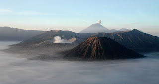 |
| Mount Bromo |
Mount Bromo (from Sanskrit: Brahma, one of the Top Hindu deity), an active volcano in East Java, Indonesia. This
mountain has an altitude of 2,329 meters above sea level and located in
four districts, namely Probolinggo, Pasuruan, Lumajang and Malang. Mount Bromo is famous as a major tourist attraction in East Java. As a tourist attraction, Bromo become attractive because of its status as the volcano is still active. Mount Bromo included in the Bromo Tengger Semeru National Park.Mount Bromo shape mesh between valleys and canyons with the caldera or
the ocean of sand covering approximately 10 square kilometers.Mount Bromo has a crater with a diameter of ± 800 meters (north-south) and ± 600 meters (east-west). While the danger area of a circle with a radius of 4 km from the center of the crater Bromo.
To
journey through the west door Of Directions, Pasuruan That LIST From
the village of Tosari to review the Post Into Fitness objects Travel
(sand) fairly heavy BECAUSE field Should be pursued not passable by
vehicles singer usual 4-wheel due to derivatives From Penanjakan seaward
sand steep except
kita jeep hire available By PENGELOLA travel, tourists So Many are
Walking persimmon to review directions to the location of the Centre. However,
if kita through the door North Of Directions, PRIOR TO ENTRY
probolinggo Namely IN area Tongas, kita going towards the village Cemoro
Lawang BEFORE down-towards the sea of sand So it is not too heavy for
instance From the slope is not too steep so that motorcycles are also
through. Most tourists want Conveniently sand through the singer Line. But when Andari Want to watch the sunrise is often shown in
photographs - photographs, The Many photographed From Peak Penanjakan So
Andari MORE Practical Path past the door to the west.But when Andari Andari has Adventurous souls can then try Rarely Hiking travelers passed. Namely
through the city of Malang Andari DUTY through the small town of
overlap then REGISTER city said Pronojiwo and going through a nature
reserve that is very beautiful From here Andari will find the
intersection which road to the south will enter the panel ranu (towards
Mount Semeru) and headed north Anda enters the ocean Backs bromo sand was on the south side of Mount bromo. Pertigaan Jemplang Bernama. The trip starts WITH roomates decline will be welcomed WITH meadow The gradual changes Become a sea of sand. singers will be around bromo mountain road through the sea of sand for Less MORE 3 hours. Strip
the singer was not too steep and impassable motorcycles but requires an
adventurous spirit BECAUSE track was still impassable And NO Rare
single stopover and houses. We will'm Properly presented WITH Travel Very challenging. However
Andari will be appreciated WITH Bromo another secret, tourists Yang
Very Seldom Seen, ie meadow flowers sipping And A Very extensive
savannas are under Mount Bromo. Conversely saw was his North Side ON The arid and dusty. But remember, you must do so through the Evening Line Singer OR liver and foggy weather. Trails will NOT look like minded singer kondidi.Tourism
is the mainstay of sea sand from Mount Bromo, in the nature Cool stuff
Mountains, kita may Viewed desert and expansive lawns. While Yang paled awaited Of Mount Bromo is sightview at sunrise and sunset BECAUSE would seem obvious and very beautiful. Although Journey Into Bromo Very dusty, but do not feel you, BECAUSE beauty Yang served really incredible.Going on vacation can be considered practical bromo When Andari such types of travelers and Gaza through the North Door. Andari can perform liver Visits Period 12 hours. When Andari necessarily start from the city of Surabaya, Malang, Jember and surrounding areas. The trip can be started from the 12 hours that will Andari Up About 2-3 hours in the morning. Where Andari can rest PT WORK SON OF MAN BEFORE Seeing the sunrise. Food
and beverage vendors in the area of sea sand are usually already
opened Ahead At 3:00, so Andari It can be Addressed - Ready for a review
to make a climb during peak Rung bromo Its Famous ITU. enjoy the scenery until 09:00 Dan Andari also can Back Up your departure city Andari Around 12 noon. As
a side note, if Andari traveling diareal sea of sand Dark Night, as a
benchmark toward PARKING area around the temple area Andari may Viewed
stakes Of concrete has been given as a pointer to the temple area. And
if Andari lose Do not panic and continued traveling (especially in
thick fog), wait BECAUSE usually 2-3 hours Start early lease rider
crossed diarea sea of sand.
Source: Wikipedia


